Integration, as an approach, helps to simplify things and augment the quality of a process regardless of the domain. Better outcomes are possible with the merger of two different technologies or processes and the procedure of construction is no exception. The integration of BIM (Building Information Modeling) and GIS (Geographic Information System) can bring about more feasibility and credibility in various construction projects. The unification was first brought to success within the USA. Most probably this is what has made finding a BIM Consultant in US an easier task for the project owners.
BIM and GIS are targeted to accomplish two different objectives in a construction project. While BIM is useful in modeling and coordination in a project, GIS is directed toward procurement as well as analysis of geospatial data. It is evident that the merger of these two concepts can be aimed toward the insightful execution of a construction project that would be far more reliable than before.
In this blog, we are going to understand how to integrate information of BIM and GIS, their advantage, and the individual importance of both.
How BIM and GIS are vital to the industry of construction?
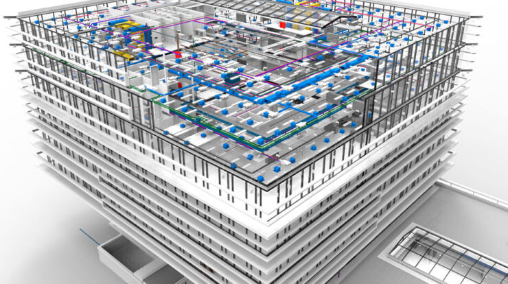
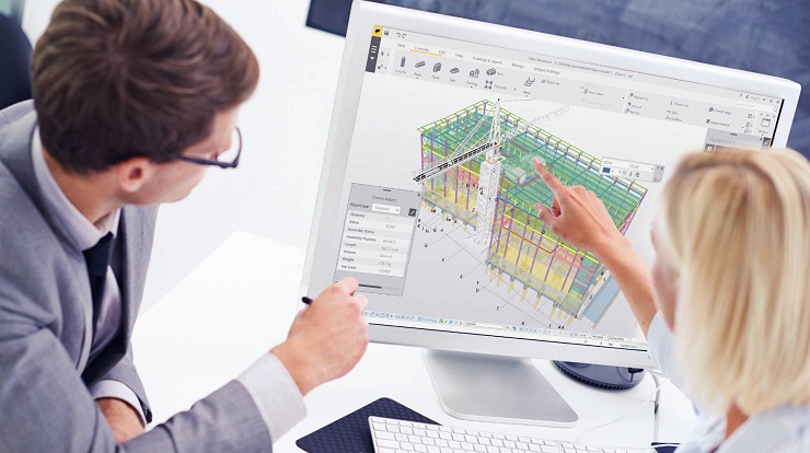
To understand their integration, one has to get back to the crux of BIM and GIS to further explore their vitality. BIM is a process while GIS is a system. BIM is useful in depicting the fundamental facets of a building. By using the best tools and technologies, it provides a 3D representation of the various physical as well as functional aspects of an edifice. It is a resource-based information model that helps in team collaboration and document management. Lately, the fourth dimension of construction sequencing was added to the entire process.
In a construction cycle, GIS-based information is useful in the development of credible structures. A computer-based system, GIS helps in the collection and analysis of geospatial data. As the location can impact a project cycle massively, GIS helps in making more informed decisions regarding the same. The stakeholders can receive genuine inputs on crucial parameters including management of the project cycle, operations, and maintenance.
Together, BIM and GIS are great tools in hands of the stakeholders during a construction process, from start to end. GIS offers data that is based on the geographical location where the construction process is going to be executed. As the data is shared with all the major participants, of the existing environment, in real-time, the scope of exploration becomes better which helps in the creation of an improved design. When BIM and GIS are put together, the project managers are able to build a better understanding of a construction cycle, its outcomes, and future maintenance.
How the integration of BIM and GIS would take place?
The integration of the BIM process with the GIS system would be valuable in the multiple stages of planning and execution of a project cycle. One can understand it better with the application of their fusion that is mentioned hereunder.
Effective Management of Resources
A big budget, massive effort, and extensive-time period have to be put in for the construction of a building. Any mismatch between the location of the construction and the type of material being put to use is going to cost a lot of time as well as effort of the stakeholders.
GIS merged with BIM would let the project manager make better decisions around the resources that are required for the execution of the project. By minimizing the scope of glitches, the fusion can help in the effective usage of time and effort. Besides, the projects get freedom from cost overruns and unnecessary time delays.
Enhanced 3D Visualization
BIM-GIS would provide more detailed data about different components of a project cycle. As the information is a 3D representation, it offers better visualization that enhances the processes of planning and implementation. The managers and investors would be able to observe the model better with an advanced design.
The integrated model would help the stakeholders to visualize the infrastructure with detailed information about the surroundings. A central analysis of the spatial data would be possible with the BIM-GIS model. Therefore, the major participating entities would be able to share their inputs on the real-time data shared through the cohesive process.
Clash Detection
No matter how big or small is a project, repair and upkeeps would be common in different stages of operation. Information on utility was required to carry out the tasks of renovation and maintenance. Provision of utility information was not possible earlier or it was obtainable in 2D CAD drawings. A clash is possible among the utilities, as the extraction of insights on utility was not possible with 2D drawings.
With the integration of BIM-GIS, clash detection has become feasible with the aid of the BIM process. The tools like Navisworks, Civil 3D, etc. make clash detection much easier. The 3D representation offers information in a way that could aid in more informed decision-making.
How BIM-GIS integration is going to be beneficial?
The integration of a groundbreaking process and an effective system would offer many advantages to the construction industry. These are mentioned below.
- The return on investment would be bigger with the combination of BIM and GIS.
- It would facilitate the collaboration, much better, including the different stakeholders.
- A construction cycle becomes better with valuable geospatial data.
- Informed decision-making would be facilitated which would enhance the overall process of construction including planning and execution.
- Smarter designs of the building would be possible that would ensure efficient infrastructure for the buildings.
- Efficient usage of time, effort, and costs is viable with the integration.
- The architects would be able to offer better designs with a robust infrastructure for the construction of better and stronger buildings.
- Integration would make it possible for the project managers to analyze the data for making improvements for minimizing any cost failures.
Final Remarks
It would be better to say that a GIS-based BIM model in construction can lead to better planning, effective execution, and easy maintenance of many projects. The innovation furthers the scope of improvisation in a project as the merger provides an information-rich model. The mapping features of GIS can tremendously impact the overall cycle of a construction project.

With over 16.8 million Coronavirus cases in Read more
Any Product Owner needs a BIM consultant Read more

The field of building construction over the Read more