In today’s dynamic and interconnected world, Geographic Information System (GIS) emerges as a cornerstone of spatial data management and analysis. GIS has proved itself from urban planning and environmental conservation to public health and disaster management. It advances every aspect of modern society revolutionizing how we perceive, analyze, and interact with geographical information.
Geographic Information System refers to a framework designed to capture, store, manipulate, analyze, manage, and present spatial or geographic data. It encompasses a wide array of technologies, processes, and methods, amalgamating geographical data with non-spatial attributes to facilitate informed decision-making.
This article delves into the multifaceted realm of GIS, elucidating its core functions, applications, and prospects.
Understanding GIS
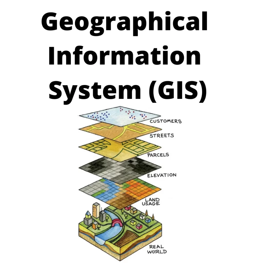
GIS operates on the fundamental principle of spatial analysis, wherein it integrates geographical data from various sources. It includes satellite imagery, aerial photography, GPS, and survey data. Through this, GIS enables professionals to discern patterns, trends, and relationships within spatial data. Hence, fostering a deeper understanding of geographical phenomena.
GIS encompasses a myriad of functionalities, including data capture, storage, manipulation, analysis, and visualization. Data capture involves acquiring geographical data from disparate sources, such as remote sensing, GPS, and surveys, and converting them into digital formats compatible with GIS software.
Components of GIS
Here are enlisted all the major components of GIS:
Hardware: This includes the essential hardware components required for GIS operations, such as computers, servers, GPS receivers, and other peripherals.
Software: Explains the various software tools used in GIS, including geographic information systems software. For example, ArcGIS, QGIS, and open-source GIS software. Describe their functionalities and capabilities.
Data: Highlights the importance of spatial data in GIS. This involves vector data (points, lines, polygons) and raster data (imagery, elevation models). Discuss data formats, sources, and acquisition methods.
People: Emphasizes the role of individuals in GIS, including GIS analysts, technicians, developers, and users. Discuss their responsibilities, skills, and expertise required to work effectively with GIS technology.
Methods: Explores the methodologies and techniques used in GIS, such as data collection, digitization, georeferencing, spatial analysis, and visualization. Discuss how these methods are applied to solve real-world problems.
Procedures: Outlines the workflows and procedures involved in GIS projects. It also helps in data processing, analysis workflows, map production, and quality assurance/quality control measures.
Standards: Discusses the importance of standards in GIS, such as data standards (e.g., FGDC, ISO), metadata standards, and interoperability standards (e.g., OGC standards). Explain how adherence to standards facilitates data sharing and integration.
Networks: Touches upon the role of networks in GIS, including communication networks for data sharing and collaboration. It also enhances spatial networks for routing and network analysis.
Data in GIS- Types and Sources
Talking about the types and sources of GIS, let us tell you that instead of being a new technology. GIS is enriched with various advanced types and sources.
Vector Data
Vector data in GIS consists of points, lines, and polygons representing geographic features with attributes, allowing for precise spatial analysis and visualization.
It’s commonly used to model real-world phenomena such as roads, rivers, and administrative boundaries in a digital environment.
Raster Data
Raster data in GIS consists of a grid of cells, where each cell holds a value representing information. For example, elevation, temperature, or land cover.
This format allows for detailed spatial analysis and visualization. This make it suitable for applications like satellite imagery analysis and terrain modeling.
Tabular Data
Tabular data in GIS refers to structured information organized in rows and columns, often accompanying spatial data to provide attribute details.
It complements spatial data by offering additional insights such as attributes, characteristics, and other non-spatial information crucial for analysis and decision-making within Geographic Information Systems.
Remote Sensing Data
Remote sensing data in GIS involves capturing information about the Earth’s surface using sensors mounted on satellites or aircraft, enabling the creation of detailed maps and analysis.
It provides valuable insights into land use, vegetation cover, environmental changes, and more, enhancing the capabilities of Geographic Information Systems.
GPS Data
GPS data in GIS refers to the geographic information collected by Global Positioning System satellites, providing precise location coordinates that are utilized for mapping, navigation, and spatial analysis within the GIS framework.
This data enables the accurate depiction of features, assets, and phenomena on maps, facilitating informed decision-making and spatial understanding across various fields.
Publicly Available Data
Publicly available data in GIS refers to geographic information that is accessible to anyone without restrictions, enabling users to analyze and visualize spatial phenomena for various purposes, from urban planning to environmental monitoring.
These datasets, often provided by government agencies, NGOs, and research institutions, play a vital role in fostering collaboration, research, and informed decision-making within the GIS community.
Crowdsourced Data
Crowdsourced data in GIS refers to information collected from a diverse group of individuals or sources, enhancing the richness and depth of geographic datasets.
By harnessing the collective knowledge of the crowd, GIS applications can incorporate real-time updates, community insights, and local expertise for more accurate and dynamic spatial analysis.
Field Surveys and Ground Truthing
Field surveys and ground truthing play crucial roles in GIS by collecting accurate, real-world data to validate and enhance the reliability of spatial information.
Through direct observation and measurement on the ground, GIS practitioners ensure the fidelity and relevance of their geographic datasets, enabling more precise analysis and informed decision-making.
GIS With Spatial Data
By overlaying different layers of spatial data, GIS facilitates the identification of spatial patterns, correlations, and anomalies, empowering users to derive actionable insights. Subsequently, GIS facilitates the storage and management of spatial data in centralized databases, ensuring accessibility, scalability, and data integrity.
GIS also provides powerful analytical tools for spatial analysis, enabling users to perform various operations, such as proximity analysis, spatial interpolation, and network analysis, to extract meaningful information from geographical data.
Applications of GIS
Urban Planning and Development: Urban planners utilize GIS to analyze population trends, land use patterns, transportation networks, and infrastructure planning in cities. By integrating spatial data, planners can make informed decisions regarding zoning regulations, housing developments, and public amenities to support sustainable urban growth.
Environmental Management: GIS plays a crucial role in monitoring and managing natural resources, tracking changes in land cover, assessing biodiversity, and analyzing environmental impacts. Environmental managers use GIS to identify sensitive ecosystems, monitor pollution levels, and plan conservation efforts to mitigate the effects of human activities on the environment.
Emergency Management: In emergency situations, GIS provides critical support for disaster preparedness, response, and recovery efforts. Emergency managers utilize GIS to map hazards, identify vulnerable populations, plan evacuation routes, and allocate resources effectively during natural disasters such as hurricanes, wildfires, and floods.
Agriculture and Forestry: GIS technology is employed in agriculture for precision farming, crop monitoring, soil analysis, and yield prediction. Forestry professionals use GIS to manage forest resources, monitor deforestation, assess wildfire risks, and plan sustainable logging practices to conserve biodiversity and maintain ecosystem health.
Public Health: GIS is a valuable tool in public health for disease surveillance, outbreak investigation, and healthcare planning. Health professionals use GIS to map disease clusters, identify high-risk areas, analyze healthcare access disparities, and plan vaccination campaigns to prevent the spread of infectious diseases and improve community health outcomes.
Challenges and Limitations of GIS
Data Quality and Accuracy: GIS heavily relies on the quality and accuracy of input data. Inaccurate or incomplete data can lead to erroneous analysis and decision-making.
Data Integration: Integrating diverse data formats and sources can be challenging, especially when dealing with data from different organizations or systems.
Cost of Implementation: Setting up and maintaining a GIS infrastructure, including software, hardware, and personnel. Though it can be expensive, particularly for smaller organizations or developing countries.
Technical Complexity: GIS software often requires specialized training and expertise to use effectively. It often limits access to those with the necessary skills.
Privacy and Security Concerns: GIS data often contains sensitive information about individuals, communities, or infrastructure. Ensuring the privacy and security of this data can be challenging.
Spatial and Temporal Scale: GIS analysis may not always be suitable for very large or very small spatial scales. Temporal analysis may be limited by data availability or resolution.
Interoperability: Ensuring compatibility and interoperability between different GIS platforms and systems can be difficult, hindering data sharing and collaboration.
Ethical and Social Implications: The use of GIS technology raises ethical questions related to surveillance, discrimination, and environmental justice. These processes must be carefully considered.
Environmental Impact: The energy consumption associated with running GIS servers and performing the spatial analysis can contribute to environmental degradation, especially if powered by non-renewable sources.
Accessibility and Inclusivity: Ensuring that GIS tools and data are accessible to all users. This also includes those with disabilities or limited internet access, is an ongoing challenge.
Conclusion
GIS emerges as a transformative technology with far-reaching implications across diverse domains. From environmental conservation and urban planning to public health, disaster management, agriculture, natural resource management, and transportation planning, empowering stakeholders with spatial insights to address complex challenges and make informed decisions.
As we navigate the geospatial frontier, the role of GIS will continue to evolve, and drive innovation. It fosters collaboration, and shapes a more sustainable and resilient future. With its unparalleled ability to harness the power of geography, GIS remains an indispensable tool for understanding our world and charting a course toward a more prosperous and equitable future.
FAQs
- Who is the father of GIS?
Answer- Dr. Roger F. Tomlinson is credited with originating the phrase “geographic information system (GIS)” and pioneering the development of the first computerized GIS during the 1960s while employed by the Canadian government. His creation, a geographic database, remains in use by numerous municipalities throughout Canada for land planning purposes.
- Who first used GIS?
Answer- Roger Tomlinson’s groundbreaking efforts led to the establishment of the world’s inaugural computerized GIS in 1963. His efforts includes conceptualizing, organizing, and building the Canada Geographic Information System. Tomlinson pioneered the development of this innovative system. It is also tasked by the Canadian government to compile a structured inventory of its natural assets,
- What is the scope of GIS?
Answer- GIS technology enables the creation and maintenance of digital maps. It offers diverse visual representations of spatial data, such as maps, charts, and graphs. This facilitates the comprehension of spatial trends and patterns, empowering users to make well-informed decisions derived from the data.

The construction sector is one of the Read more
Mechanical, electrical, and plumbing systems (MEP) today Read more

Imagine donning a pair of sleek glasses Read more