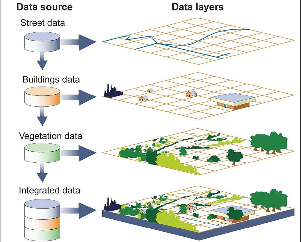
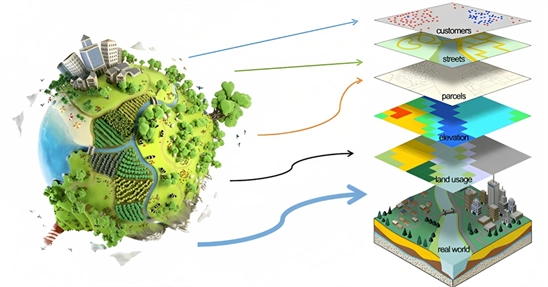
GIS can reflect different kinds of data on a single map. This includes the streets, buildings, and vegetation. The easy evaluation of analytics it provides, allows planners to be able to better analyze and understand present patterns. Thus, different uses of GIS contribute to making informed decisions.
The uses of GIS comprises better visualization, which makes the identification of different trends and patterns easier. Correctly leveraging GIS capabilities can solve design and planning problems in the urban landscape. In the 21st century, GIS contributes to solving urgent and complex challenges.
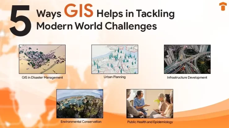
To gain more perspective on GIS, the section below outlines its uses across various fields.
GIS in Disaster Management
Source: sgligis.com
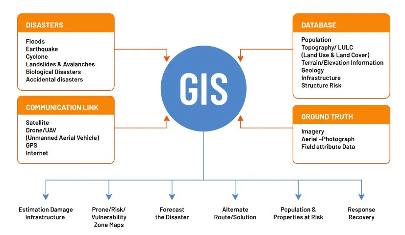
Considering the increasing number of both natural and man-made disasters, there is an ever-growing need for disaster preparation. Because of modern technology, there are reliable and effective solutions available. And GIS in disaster management has turned out to be the most critical of them all.
GIS in disaster management enables the presence of valuable tools that enable the thorough simplification of geo-spatial data. One of the key uses of GIS is that it offers to conduct risk assessments. It can be done by identifying historical patterns of disasters in the area. In this way it becomes easier for planners to identify high-risk areas and plan accordingly.
GIS allows for analyzing real-time data in the event of disasters and enables response teams to quickly answer distress calls. It gathers data from multiple sources, including satellite imagery, social media feeds, and sensor networks, which improves the mapping of the affected areas.
This makes it easier for them to estimate the population density in affected areas and look for possible evacuation routes. GIS in disaster management contributes significantly in conducting post-damage assessment. This enables quantifying the extent of damage and assessing recovery efforts.
GIS in Urban Planning
Source: geospatialworld.net
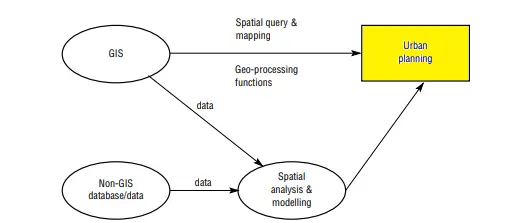
GIS in urban planning is mostly associated with guiding the process of decision-making. It is to develop designs that are sustainable and effective. It allows for the integration of diverse data based on which spatial relationships are identified, following the proposal of optimal land use strategies.
Urban planners make use of GIS in urban planning to identify potential development areas. By considering the factors such as demographics, land use, available transportation networks, etc. Each of these factors is utilized in creating a comprehensive mapping framework to achieve improved efficiency and better quality of life for residents.
GIS in urban planning facilitates a better understanding of the complexities associated with urban dynamics. It considers the vulnerability associated with urban areas regarding population explosions, scarcity of space, vulnerability to natural disasters, and resource availability.
| Read More: Importance of GIS in Urban Planning
GIS in Infrastructure Development
Source: National Geographic
It is important to highlight that for the sustained and accelerated economic growth of any country, infrastructure development is crucial. GIS can be extensively used in this field because it helps in saving both administrative and operational costs.
One of the major challenges for any agency during infrastructural development consists of finding the correct resources. This is followed by a simplified design that can be both sustainable and economical. The use of GIS is that it enables providing appropriate and realistic solutions by considering several options.
Furthermore, GIS allows infrastructure experts to identify and analyze geological insecurities that are quite prevalent within urban communities. As uses of GIS are not just restricted to foundation planning and arranging, they allow for the use of several factors, such as transportation, utilities, resources, etc., when developing infrastructure designs.
At a time when rapid globalization is leading to increased infrastructure projects, implementing GIS can lead to improving its success. Moreover, GIS in itself is constantly evolving, and along with it, new trends are entering the market. The section below outlines a few future trends that will have a significant impact on infrastructure development.
- The use of Artificial Intelligence and Machine Learning
- The use of Cloud Computing
- The increased use of mobile GIS
GIS in Environmental Conservation
Source: geographicbook.com
The implementation of GIS in environmental science also has several uses. GIS technology can be successfully used to get more clarity on the level of pollution, deforestation, current forest cover, etc. GIS utilizes the use of satellite images and subsequent documentation to provide real-time data on the environment.
The use of GIS in environmental science spans the ability to map air quality during wildfires to gather data about water resources. Through the efficient use of satellite images it allows us to observe the distribution of forest cover based on which resources can be allocated for preserving it.
Thus, the uses of GIS constitutes its ability to map geographical terrain that can aid in conserving the environment. Hence, the use of GIS technology can be considered to be crucial for helping create an inventory of all plants and wildlife.
GIS in Public Health and Epidemiology
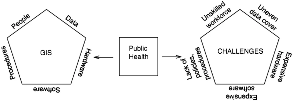
Source: Cambridge University Press
The GIS used for epidemiology is mostly associated with its ability to map epidemiological data. It also includes conducting spatial interpolation of data for areas where it is difficult to have access to accurate datasets or areas that have not yet been surveyed.
As a result, the implementation of GIS will allow for more autonomy in the decision-making process regarding public health because of better mapping. This is because it will allow for support in determining the health situation in an area, identifying high health-risk groups, monitoring and evaluating the interventions, and so on.
The use of GIS in the sphere of public health is its ability to determine the patterns or differences with regard to health situations. This is mostly across different levels of aggregation, including hemispheric, national, district, regional, or local levels. GIS will enable the mapping of health indicators across all these areas and, in turn, contribute to determining the mortality rates.
| Also Read: The Integration of GIS with BIM: An Explanation
Conclusion
Hence, it is quite evident that in the current evolution of technology, data has become an indispensable part of our everyday lives. Harnessing the technology of GIS correctly will lead to better mapping of geospatial data that can improve decision-making and problem-solving skills.
The uses of GIS, ranging from urban planning and management to conserving the environment, showcase the range of possibilities associated with it. It enhances the ability of our society to facilitate collaboration, which has a strong positive impact on improving our quality of life.
Technostruct is committed to providing knowledge and insights on how GIS can contribute to improving our society. It is committed to offering a variety of expert GIS solutions to our clients to transform your projects and make it more innovative.
FAQs
Q1. How is GIS applicable in Public Health?
Ans. GIS can provide accurate and comprehensive knowledge about the origin of diseases. For example, through its geo-spatial mapping, it can answer questions related to where the disease is prevalent, where the vulnerable populations reside, where the resources are required most, and so on.
Q2. What kind of applications of GIS are present in environmental monitoring?
Ans. In the sphere of environmental monitoring, GIS contributes to identifying and assessing environmental risks from different sources: water, atmosphere, and land. It also considers geological and geomorphological data of the area in question to provide a more accurate analysis regarding the extent of damage.
Q3. Can GIS be used in Wildlife Management?
Ans. GIS can be utilized in the field of wildlife management by helping examine and envision wildlife movement and habitat ranges. In this way, it becomes easier to gain clarity on the specific needs of the wildlife population in question, leading to better rehabilitation and habitat restoration.
The construction sector is one of the Read more
Mechanical, electrical, and plumbing systems (MEP) today Read more

Imagine donning a pair of sleek glasses Read more