The construction industry has become more complex today, with the use of sustainable designs and models that will have a positive impact on the environment. The integration of technology has further made it possible to look for cost-effective approaches that can lead to better scheduling and management.
The dynamic nature of the construction sector has been further enriched with the integration of BIM technology. However, aside from BIM, there is another new technology that is creating waves in the construction market.
Geographic Information Systems or GIS has a wide range of applications ranging from project development to land planning. In this blog, an outline of the meaning of BIM and GIS has been provided, along with its importance and benefits in the current market.
What do you understand about the terms GIS and BIM?
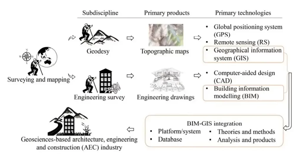
Geographic Information System (GIS) belongs to a branch of IT (Information Technology) that is utilized for the management of spatial and non-spatial data. The use of this system helps in the creation of a database that is associated with construction resources. It is also associated with managing safety along with providing recommendations for quality control.
Building Information Modelling (BIM) is defined as a digital workflow process that is utilized for the designing, planning, management, and construction of different infrastructure projects. Through the use of this model, it becomes possible to optimize the projects and develop a sustainable construction model.
The need for Integrating GIS into BIM
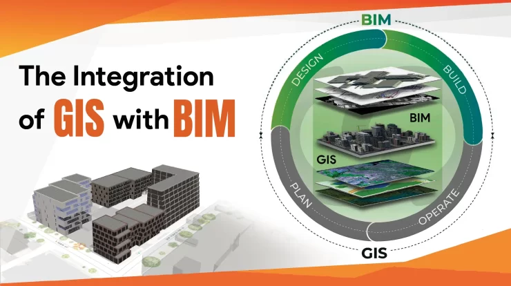
The integration of GIS with BIM is gradually becoming a new trend in the market. The advantages that BIM provides in the form of advanced geometric and semantic information is improved through GIS. The latter has a lot of benefits in the form of helping develop geospatial modeling and geo-visualization based decision making processes.
Comparison of the progress of evolution of GIS, BIM and Integrated GIS-BIM
The importance of integration is also associated with the fact that it contributes towards its ability to design smart cities. The combined capabilities range from conducting quantitative analysis, urban management, data integration and the application of technologies.
The integration of BIM-GIS in construction has gained momentum in the last decade both from research and in industrial sectors. The reason has mostly been because of its ability to integrate data and information with multiple spatial scales. This makes it easier to identify and address problems that are related to construction components.
Why is GIS an Effective Tool?
The Geographic Information System is a computer-aided program that mostly produces maps and databases based on which a sustainable construction plan can be developed. It is considered to be one of the most essential tools today in the fields of Engineering, land surveying, geology, and construction, among several others.
The reason GIS is gaining rapid importance in the market is because of its accuracy. Through its integration with building information modeling, it adds better support in managing complex designs.
It is important to consider that there is a significant difference between the BIM and GIS processes. In the case of BIM, there is the advantage of being offered a detailed visualization of the project design in three dimensions.
GIS, on the other hand, offers better customization and is better equipped for conducting analysis in a multi-site environment. Another difference present between BIM and GIS is that while the former offers mapping features providing detailed geographical assistance, the latter is mostly associated with providing information based on specific objects.
How GIS integration in BIM can simplify Construction Projects?
The application of Geographic information systems is gaining popularity as it can help in monitoring the progress of any particular project activity on-site. Through this, Architects are provided with the advantage of getting information on spatial data in real-time.
Having access to map visualization offers numerous advantages for designing a project more effectively. It can also contribute towards helping corporate sustainability in the designs, using three-dimensional visualization.
The importance of GIS integration is also associated with its ability to plan and schedule projects to better manage the existing budget and resources. The data provided by GIS also offers support in managing operations and running environmental analysis, leading to better design implementation.
Is there an interrelationship between GIS and BIM?
One of the most common questions that is often asked regarding the use of both GIS and BIM together is regarding its interoperability. There is indeed a strong inter-relationship present between these two processes because it can be put together in a real-world context, leading to better and deeper analysis.
GIS provides the function of using information from several projects across several sources in different formats to be easily linked together in a common locational area. As a result, architects will have easy access to all the information that they require and easily incorporate them into the BIM software to conduct better design development.
BIM is mostly associated with managing the detailed geometrical and semantic information associated with the development of each building in the construction project. The integration of GIS allows for better management of the resources available in the construction area by analyzing the coordinates or the postal zip codes.
Benefits of integrating GIS into BIM
At a time when the construction industry is becoming more complex because of the number of people being involved, the integration of GIS into BIM provides several advantages. In the section below, an outline of the advantages associated with the integration of GIS into BIM is briefly explained.
1) Eliminating Duplicate and Redundant data
One of the major challenges faced by architects is to manage multiple sources of information when investigating construction sites. This often leads to the problem of creating duplicate entries.
At the same time, there is also the challenge of the presence of redundant data that has not been removed. The presence of this redundant information may lead to inaccurate information, causing a negative impact on design development.
This challenge is easily mitigated through the integration of GIS into BIM. The former method ensures better management of construction information from multiple sources and easily reduces any entries that are present in more than one. It takes into consideration the date of entry to determine the level of accuracy of the information present.
2) Creating better designs
One major benefit of the integration of GIS is that it leads to better data visualization. GIS Offers detailed information through Geospatial data. This data gets further analyzed from three-dimensional perspectives, helping create efficient designs.
GIS makes it easy to consider the sustainability, quality, and environmental impact that may be associated with the project. It also provides easy access to the latest information and helps to overlay the engineering design along with the existing design. It also contributes towards linking the construction field with the office, leading to better communication.
The combination of all these techniques helps improve designed development along with improving collaboration with multiple stakeholders of the different projects.
3) Better Data Exchange
Another important advantage associated with the integration of GIS into BIM is that of data exchange. Both of these systems help collect information about the natural environment and construction sites and transfer the data directly through the help of cloud storage devices.
It also leads to better decision-making as it constitutes the development of instructors who can accommodate the growth of different communities. The data exchange is carried out across four different steps: design, build, manage, and plan.
The steps of design and build are mostly utilized by BIM, helping in the creation of a single construction by integrating information collected from geospatial data. The analysis of this information is then transferred into GIS, where it manages and plans the design of the construction by considering the existing assets presented to it.
This easy exchange of data makes it possible to make informed decisions about how to create sustainable construction projects.
4) Enhancing Quality Management
The integration of these two technologies have the ability to holistically explore the potential factors associated with defects. This is made easy as the dynamic exploration is conducted during the entire construction life-cycle.
It ensures the management of information consistency starting from design to construction. This is followed by predicting if there are any spatio-temporal distributions of risk present to improve predictive decision-making.
5) Contract Management
BIM already contributes towards enhancing contract relationships through its features. It allows for optimizing construction procurement, which is made possible due to increased execution efficiency of contracts.
The integration of GIS-BIM further allows for facilitating dynamic and predictive decision-making processes. This enhances its ability to manage significant time-savings across each stage.
Conclusion
In conclusion, it can be stated that the integration of Geographic Information Systems into Building Information Modeling has a lot of benefits for the construction sector. Integration is vital both in the commercial sense and also from an evolutionary perspective.
Click here to know about the GIS services we offer.
FAQs
Q1. Does GIS implementation help manage sustainability in construction projects?
Ans. Yes, because the GIS technology allows for collecting satellite images to identify areas of risk. In this way, it helps the architects make building designs that are sustainable. Furthermore, considering its feature of accuracy, it contributes towards helping reduce the wastage of resources.
Q2. Is GIS difficult to manage?
Ans. As the software makes use of a relatively spatial database, there may be some initial challenges. It requires significant technical expertise to master its use long-term. TechnoStruct here has a host of informative resources that can help manage these challenges easily.
Q3. Is it essential to have knowledge in coding to manage GIS?
Ans. Not necessarily. It is very much possible to create maps and visualizations by just using the GIS software without having any prior coding experience.
The construction sector is one of the Read more
Mechanical, electrical, and plumbing systems (MEP) today Read more

Imagine donning a pair of sleek glasses Read more